Good Men’s Trail on Foot: Stages and Route of the GR-107
The Good Men’s Trail, also known as GR-107 and Camí dels Bons Homes, is one of the most iconic hiking routes you can undertake in the Western Pyrenees. You can complete the Good Men’s Trail on foot, a route of about 200 kilometers that not only offers a physical journey between Catalonia and France, but is also a Cathar trail full of history.
Along the way, you will enjoy a true cultural journey as you retrace the footsteps of the Cathars, known as “good men,” who centuries ago fled the religious persecution carried out between the 13th and 14th centuries.
Walking this Cathar trail is possible, but you must keep in mind that it requires experience and preparation and can take between 8 and 10 days. If you decide to try it, you will enjoy spectacular high-mountain landscapes and also learn more about the historical legacy that surrounds this Pyrenean journey.
Hiking on the GR 107
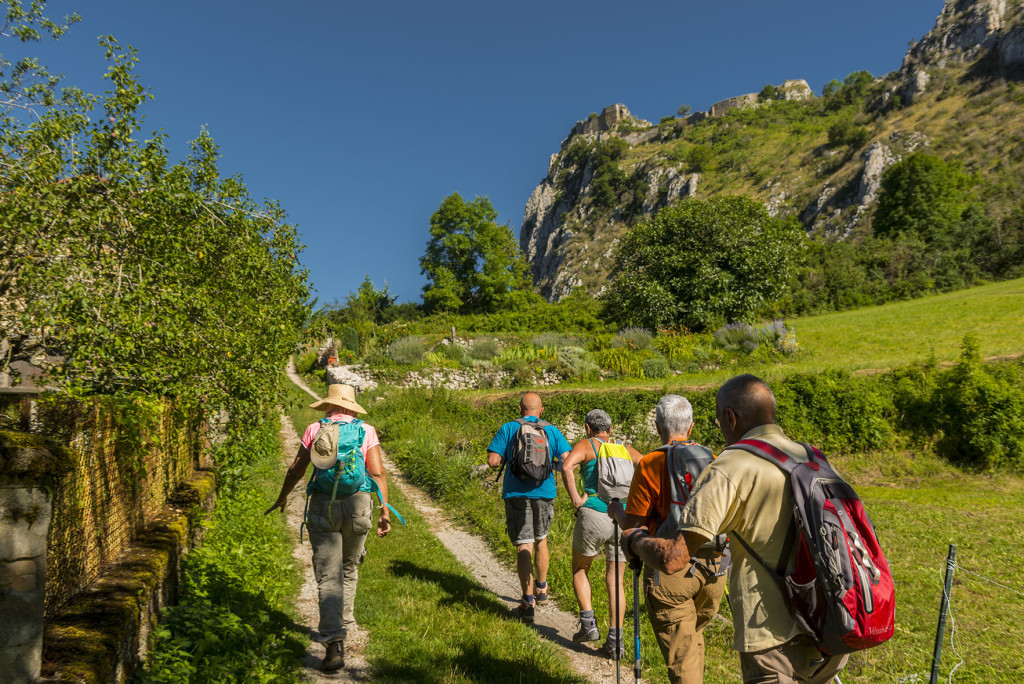
Hiking on the GR 107 is an excellent option because the route is very well marked with red and white blazes. The GR 107 connects two key points in Cathar history: the Santuari de Queralt in Berga, Catalonia, and Montségur Castle in Ariège, France.
The trail is designed to be completed in both directions, so you may start from either side. However, most hikers prefer to begin in Berga and finish at the dramatic castle of Montségur.
As mentioned earlier, the difficulty level of the route is medium-high, which means it requires a certain degree of physical preparation and is not recommended for beginners. This is due to the accumulated elevation gain, especially when crossing the Cadí-Moixeró Natural Park and, of course, the Pyrenean mountain range itself.
If you plan to hike in the Pyrenees, keep in mind that you will face long days of walking. Hikes usually last between 5 and 8 hours, with high-mountain sections located above 2,000 meters of altitude. This not only makes the journey more demanding but also means you must pay attention to weather conditions along this historic trail.
Stages of the Good Men’s Trail
One of the advantages of completing the Good Men’s Trail is that you can personalize the stages to some extent. Depending on how much you want to walk each day or where you prefer to stop, you can lengthen or shorten the stages of this medieval route. Here is a classic 10-stage itinerary, but remember it is not the only way to enjoy this great trail.
Stage 1: From Santuari de Queralt (Berga) to Gósol: 29.36 km
Stage 2: From Gósol to Bagà: 23.8 km
Stage 3: From Bagà to Bellver de Cerdanya: 21.71 km
Stage 4: From Bellver de Cerdanya to Porta: 35.52 km
Stage 5: From Porta to Mérens-les-Vals: 21.90 km
Stage 6: From Mérens-les-Vals to Orgeix: 17.97 km
Stage 7: From Orgeix to Comús: 22.65 km
Stage 8: From Comús to Montsegur: 16.103 km
Stage 9: From Montsegur to Roquefixade: 16.05 km
Stage 10: From Roquefixade to Foix: 16.78 km
How to Prepare for Your GR 107 Journey
The first thing to keep in mind if you want to enjoy this spiritual trail is that you must have good physical preparation. While the trail does not require extensive experience, it is essential to be used to walking for several hours with a backpack.
If you decide to hike the GR 107, we recommend training at least three months in advance. Practice on routes with elevation gain and carry weight, as this will be part of your daily experience on the trail.
Beyond training, your equipment is also important. This is not the kind of route where you can wear just anything—hiking in the Pyrenees means you must bring proper footwear, such as medium- or high-cut trekking boots that are well broken in and have a waterproof membrane in case of rain.
Even if you hike this nature-and-culture route in summer, it is essential to dress in three layers: a thermal layer, a fleece, and a windbreaker or rain jacket. Mountain weather can change quickly, and you must be prepared for anything.
These scenic routes are very well marked, but for safety, it is recommended to carry a physical map and also a GPS/phone with the tracks downloaded. This will be very useful in foggy areas.
To improve safety, bring a small basic mountain first-aid kit, a headlamp, and enough water or purification tablets. Carrying an energy bar or two will help you get an extra boost as you pass through the medieval villages along the way.
Accommodation and Services on the Good Men’s Trail
The Good Men’s Trail is a long route that you can walk without rushing. Thanks to its length, you will find several accommodations and services along the way that can make the walk much more comfortable.
During the high-mountain stages, you will find guarded mountain refuges, a good option that includes breakfast, dinner, and a bed—but you must book in advance. In the larger villages you pass through, such as Berga, Bagà or Bellver, there is more activity, and you will easily find hotels and rural houses, offering a wider range of options.
Additionally, you can hire luggage-transfer services. Some companies can move your bags from stage to stage. This is a great option if you want to walk lighter without carrying your entire backpack every day.
As a tip, if you plan to travel during high season, we recommend making your reservations at least one month in advance.
Mindful Experiences Along the GR 107
The history behind this route is a perfect blend of nature and culture. In several sections, you will be out of mobile coverage. You may think this is an inconvenience, but it can also be an opportunity to enjoy a much more mindful experience, away from digital noise. Perfect for deep immersion in the surroundings.
Many people walk this freedom trail and enjoy scenic routes to turn them into a form of moving meditation. Being surrounded by nature in such privileged landscapes encourages mindfulness in motion. And thanks to the physical effort required by the trail, it becomes even easier to clear your mind on these rural paths.
Finally, these are routes with history. Imagine that 700 years ago people walked these same paths out of desperation. They saw a landscape similar to the one you are seeing today, which adds an extra layer of respect and humility throughout this cross-border trail.
Plan Your Trip
Remember to plan your journey in advance so you don’t miss anything. When organizing this rural tourism experience in the Pyrenees, you must consider not only the different stages you will walk, but also which hotels or refuges you’ll stay in.
Booking everything ahead of time will help you enjoy this memorable journey even more, as you will have taken care of all the logistics before leaving home. Remember how important proper physical preparation is to fully enjoy the route, and be respectful of nature.
The Good Men’s Trail allows you to enjoy rural tourism in the Pyrenees while discovering and experiencing part of history firsthand. All of this will become an experience difficult to forget.
|
STAGE
|
DEPARTURE
|
ARRIVAL
|
KM
|
D+
|
D-
|
Temps
|
|
1
|
Queralt Sanctuari
|
Peguera
|
12
|
800
|
350
|
3 h 45 min
|
|
2
|
Peguera
|
Gósol
|
17.5
|
850
|
1000
|
5 h 15 min
|
|
3
|
Gósol
|
Bagà
|
25.5
|
700
|
1350
|
6 h 30 min
|
|
4
|
Bagà
|
Bellver de Cerdanya
|
22
|
1250
|
1000
|
6 h 45 min
|
|
5
|
Bellver de Cerdanya
|
Viliella
|
12.5
|
650
|
100
|
3 h 45 min
|
|
6
|
Viliella
|
Porta
|
23,5
|
1150
|
1250
|
6h 30 min
|
|
7
|
Porta
|
Mérens-les-Vals
|
25
|
1400
|
1800
|
8 h
|
|
8
|
Mérens-les-Vals
|
Orlu
|
18
|
700
|
1000
|
5 h
|
|
9
|
Orlu
|
Comus
|
27,5
|
1200
|
900
|
7 h 45 min
|
|
10
|
Comus
|
Montsegur
|
14
|
550
|
800
|
4 h
|
|
11
|
Montsegur
|
Roquefixada
|
16.5
|
600
|
750
|
4 h 30 min
|
|
12
|
Roquefixada
|
Foix
|
22.5
|
600
|
1000
|
5 h 45 min
|
Recommended times of year
Recommended between the months of April to October. From the beginning of December to the end of April, the sections of the southern slope of the Pyrenees that run above 1,900 m are covered in snow. On the north side (descent from Portella Blanca to Foix) the snow arrives earlier in November and takes longer to disappear. If the crossing were made in winter the use of snowshoes, mountain crampons and poles may be necessary.
Route designed to be done on foot.
If you want to do this route by mountain bike, you must follow the alternative route that We indicate in the MTB section, it is an itinerary not marked on the ground as is the route in foot (GR 107). We recommend that you follow the track by mountain bike, because the itinerary differs considerably from the pedestrian route.
Counties
Berguedà, Cerdanya, Pyrenees Orientales (Porta) and the department of Ariège (France)
Difficulty
Although it is not a very demanding sporting route, the stages are long. and with unevenness. To do it comfortably you need to be physically well prepared and have some experience on long routes.
Variants
The track you have here is available of the entire route, only considers the main paths and not the variants. If you are interested in any variant, we recommend that you go to the specific stage and here you will find the track and description of the variant.
Protected natural areas that the route crosses
Serra de Queralt Area of Natural Interest
Area of Natural Interest Serra d'Ensija-Rasos de Peguera
Cadí-Moixeró Natural Park
Segre-Prullans River Nature Reserve
Area of Natural Interest Tosa Plana-Puigpedrós
Catalan Pyrenees Regional Natural Park (formerly Eastern Pyrenees)
Gorges of Fraud
Orlu Nature Reserve
Cartography
In the recommendations for each stage, reference has been made to the cartography of hiking utility available on the market, especially 1:25,000 scale maps.
Occitan place names
We have always tried to mention the original topography of the places, Catalan and Occitan. The first time, at least, that Occitan toponyms are cited is in their original Occitan form accompanied by the official French form (in parentheses and in italics).
Topics
Nature / Culture / Sports / Well-being
The stages step by step
You can consult the technical details of each of the stages here.